• Notice for iPhone users: DO NOT use the image size reduction option when uploading photos to the forum. This causes portrait images to post as landscape. We have added a warning to the image insert pop-up as well.

Starting on a journey

ducktapeguy

CJ-8 Member
BENEFACTOR
Lifetime Member
Member
City
SoCal
State
CA
1784878517641.png

It's been a long time coming, but it's finally ready. It took my almost a decade to find one, and another decade to get it working right, but I can say my jeep is finally done. Well, maybe not done, but not a work in progress anymore.
 
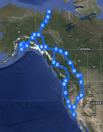
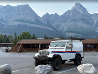
I posted this under the trip report section because I'm planning on making this a travel log. I've never written a trip report before so bear with me. I'm currently on a trip to drive my jeep to the Artic ocean and Alaska. Total mileage is somewhere between 8k-9k depending on detours and rescheduling. This was always the plan when I bought my jeep 20+ years ago, I just don't remember what came first. I might have bought the jeep and then wanted to take it to Alaska, or I wanted to drive to Alaska and decided I needed an Alaskan Postal to do it. Either way it's happening. I do plan on stopping by the Wasilla museum of transportation to go check out the other postal there and maybe take a picture with it.

1784957235127.png

My post are probably going to be pretty short for now since I'm putting in long miles for the first week. I'll post up some pics taken along the way when I have time. I also managed to schedule this trip for the absolute worst time of the year, going through Nevada in the middle of a heat wave without air conditioning was a real experience. If you've seen my other recent post you'll know what I'm going through.
 
Exciting trip, look forward to following your post. This is a dream trip so we are all going to need lots of photos. Safe travels…
 
Looks like a fun and exciting trip. Would love to do that one day.
 
Lots of camping I expect. What do the letters on the map stand for?
Those are just stop along the way I put in as waypoints to route the way I want. Google maps will take you on the fastest route, but that's not always what I wanted.

The plan is a mix of wild camping, established campsites, and hotels. I didn't make any reservations because I didn't want to be stuck on a schedule, so the plan is to just drive and find a place to stay for the night
 
Last edited:
To give you a little background, I'm taking this trip with my teenage son right now. I was supposed to do this trip last year with some friends in a caravan, but due to other issues I had to postpone it. Unfortunately, our schedules didn't sync and my friends weren't able to make it this year and I didn't want to postpone it again so here i am.

First day - I was originally planning on leaving SoCal and heading up through Vegas to the Extraterrestrial highway and pass by Area 51. I did that trip about 30 years ago and wanted to stay at the Lil Ale inn again. Unfortunately the west coast it going through a bit of a heat wave, and the though of going through Las Vegas in 105-110 degree heat with no air conditioning didn't sound like a good start to the trip.

1785129851689.png

So, at the last minute I switched plans and went up the Eastern Sierras through the Owens valley (for those not familiar with California that's skirting the left edge of the hot zone in the above pictures. The ridge of cooler temps in that picture are the Sierra Nevada mountains). Still in the mid 90's, but not life threatening. I don't have many pictures from the first day, I was busy trying not to die from the heat. But my son happened to take one somewhere along the 395.

1785130208532.png

First night was spent camping at a random hot spring in the middle of Nevada.

1785130544667.png

Obligatory Jeep shot with hot springs in the background

1785130671622.png
 
Last edited:
Day 2 - Second day was a little more interesting, as good as it gets in the middle of Nevada I guess. The first 3-4 days was spent just trying to get out of the hot zone as fast as possible, so lots of miles and fewer stops.

First stop was the world scariest motel in Tonopah. I'm a sucker for these types of road side attractions, so I've been wanting to visit this place for years. I don't think I'm scared of clowns, but I also don't know if I could spend the night in one of these rooms.

1785131514287.png

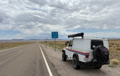
Had to take a picture next to this sign. Luckily I upgraded to a 30 gallon tank.
1785131794600.png

I hadn't had any problems up to this point, but heading up to Elko the stalling seemed to be happening more often. So somewhere along Highway 50, the lonliest road in America, I got to change the ignition coil in 90+ degree heat.

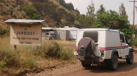
One of the first real "destinations" i wanted to visit was Jarbridge, nicknamed the most remote town in the lower 48. Coming from the Nevada side, it's 40 something miles of unpaved roads. As you can see, the ignition coil wasn't the problem. Also, if you look closely at the sign, you can see the sticker my daughter made for our trip..

1785132877952.png

Even though it took a few hours longer than expected, the drive in was amazing.
1785133152404.png

After eating at the (only?) restaurant in town, we decided to head out. I had planned on camping somewhere near town, but with the stalling problems I was having I thought it would be better to drive out during the cooler hours of the evening. Luckily the road north out to Idaho as much easier than the drive in, but we still had to stop a couple of times to let the engine cool down.

Made it to Twin falls idaho that night, where i picked up a CTS sensor and changed it in the parking lot on the edge of the Snake River Canyon.

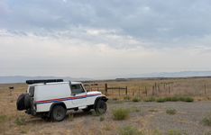
Obviously with all the issues I was having with the jeep, I decided the best course of action was to keep driving, but do it at night when the weather was cooler. So we kept going further north where we were supposed to camp at Silver creek near Carey ID. But when we got there the bugs were so bad that we ended up just camping on some random dirt road off the highway

1785133982564.png
 
Last edited:
You are definitely on a grand adventure! The Jeep is looking great and it seems like you have the right attitude to pull this off.

Thanks for posting your updates here. I will be eagerly following your journey.

I know that heat and how torturous it can be. In 2024 when going to the Colorado Scramble in Silverton, my tow rig broke down and I drove with my wife in the Scrambler with a soft top and no AC from Redding in Northern California to Silverton, CO then to Ketchum Idaho and back down to Redding. Put 3K miles in on that trip and going through Nevada and Utah at 105+ degrees was brutal. Your trip is much longer than that.

On your way back into California, it looks like you might be heading South through Redding, CA on Interstate 5. Hit me up and we can get the Scramblers together and grab coffee or a meal.

Best of luck!

George
 
I haven't planned out my return route yet, but I'll definitely be coming back through Vancouver area so will let you know my schedule. I've already driven the whole west coast up to Vancouver so I may take the inland route if the weather is not too bad.

I'll need to catch up on the trip report later tonight when I have more time.
 
Fantastic. A journey most of us can only get inspired by. Travel as safe as possible then just say F... it. Bears and such taste better with spray (I use pam with herbs). Keep us posted all the best.
 
Alright finally have some decent wifi to post more pictures

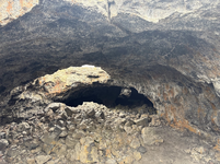
Day 3 - Headed up to Craters of the Moon National Monument where we stopped to stretch our legs with some hiking and exploring the lava tubes. Pictures can't really do the area justice so I won't try and post too many.

1785395348229.png

1785395566742.png

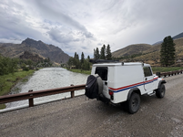
From there it was a straight shot north following the Salmon and Bitterroot river stopping at some of the small towns along the way. It was here that we first started to encounter rain. Not too much at first, but a steady moderate rain that really gave the windshield wipers a workout. This is when i first started to notice a new problem, the windshield wipers would occasionally lock up.

1785395949218.png

Because of the rain we decided to skip the campground for the night and got a room in Missoula.
 
Day 4- This was one I was looking forward to. Continued heading north into Kalispell where we grabbed a quick bite to eat then onto Glacier national park. Spent a few hours making the usual tourist stops at the lake and waterfall viewing points, but the real goal was to get to Logan pass and hike the Highline trail. Pic below stolen off the internet.

1785396672720.png

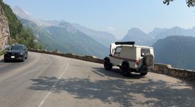
Unfortunately Going to the Sun road and Logan pass beat us. The jeep stalled about halfway up the road. If you look real closely you can see the road in the background climbing the mountain and our destination Logan pass is that notch in the mountains right above the Jeep. We sat there for about half and hour trying to decide whether to continue or turn around, but considering it was in the high 80's and we still had another 2300 feet of elevation to climb at a 6% grade, and the Going to the Sun road is a heavily trafficked with one lane each way with few turnouts, I decided it was probably best to turn around and try another time.

1785396804786.png

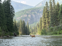
Even though it was a big disappointment, we still had fun just sitting by the stream and watching the wildlife for a few hours while we contemplated our next move.

1785397154598.png

Ate dinner near the entrance to West Glacier when I found a really useful website.

https://www.flattestroute.com/

Perfect for anyone driving an older unreliable jeep that doesn't like hills. So plugging in our destination I see there's the option to circle around the south end of the park to get to the other side. Still requires some hills, but not nearly as bad as Going to the Sun road.

Passing the continental divide (barely)

1785397657861.png


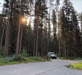
Camped that night on the Blackfeet Indian reservation.

1785397754565.png
 
Day 5 - I don't have that many pictures from day 5. Crossed into Canada at Carway with no issue. Obligatory first stop was at Tim Hortons for a couple of donuts. Then just shopping for supplies at the supermarket and Canadian Tire. Lost my gas cap somewhere along the way, luckily I carry a spare because it's been known to happen before.

Because we had been putting in some long tough days in the last week I let my son decide what to do for the day. We were supposed to do the downhill karting at the Olympic stadium, but unfortunately when we got there they had closed due to the air quality. Similarly for outdoor mini golf and a few other things he wanted to do. So after going back and forth across town a few times we ended up at an indoor mini golf/arcade.

However, that day I was able to score a last minute campsite at Banff so off we went to camp for the night

1785398365259.png
 
Day 6 - Wanted to get some excercise after all this driving, so we started the morning by hiking Johnston canyon trail to the upper falls.

1785398579558.png

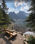
Then off to Lake Louise to hike to the Lake Agnes Tea house.

1785398636831.png

Those two hikes took up a majority of the day, so by the time we ate dinner we still hadn't left Banff. Ended up driving most of the Icefields parkway later in the evening which wasn't bad, but I wish we had more time to stop and explore.

1785398811619.png

On the way out to Hinton, the skies lit up and then it really started to pour. I wish I could post some videos of the lightning that we had on the drive out. It was at this time that issue with the windshield wipers started becoming a big problem. Even though I had tested the wipers at home, I never really needed to use them very often. Now I was really putting them through some hard use, and things started failing. They would constantly lock up on every stroke. I ended up popping the plastic covers off so I could reach in there and unlock them without having to go outside. Not fun to be driving out at night on a twisty road during a rainstorm and having to keep one hand inside the windshield frame to manually operate the wipers.

Spent the night at a hotel again since it was raining.
 
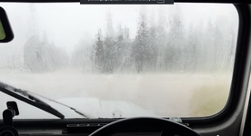
Day 7 - After a week on the road and covering over 1700 miles my memory is getting a little hazy. All the days seem to run together and I can't really remember what happened. All I know is it rained, a lot. And it's been raining almost everyday since. This is the view from my windshield after pulling over because the windshield wipers couldn't keep up and my arm was tired from constantly having to keep pressure on the connecting rod of the wipers.

1785399873135.png


1785399799633.png

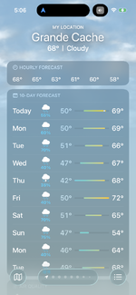
Forecast wasn't looking so good, so somewhere in Grand Prarie or Grand cache, I stopped by the Home depot to pick up some items

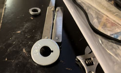
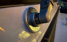
I looked up the problem with the windshield wipers online and the issues seems to be the frame flexes too much and allows the pivot arm to go over center. So after getting a bag o washers, and some creative filing with a multitool, here's my fix.

1785400111638.png
1785400203436.png

This stops the metal from deforming around the pivot linkage, but the bigger problem is the over rotation of the pivot. To temporarily solve that, I used a zip tie on the stop tab so it can't rotate as far. No pics but if you've ever had this issue you know what I'm talking about.

Spent another night in a hotel due to the rain. But at least on the bright side my jeep hasn't stalled in a few days.
 
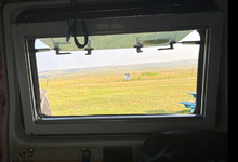
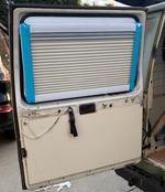
Forgot to mention one of my favorite additions. A while ago my rear window shattered, and finding a replacement is next to impossible. I had replaced it with a piece of plexiglass as a permanent temporary repair, but never really liked it that much. I also realized after one night camping in the jeep that I needed a lot more ventilation so I started looking into gull wing windows. Of course, finding one to fit the jeep wasn't going to happen, but I did find an RV window that was pretty close. So with some extra thick plexiglass and some cutting and gluing, I was able to squeeze one in there. The best part is it comes with integrated bug screen and sun shade, so I can leave it open while sleeping in the back and completely block out light.

Overlooking a field in Montana.
1785486449469.png

1785488589708.png
 
Last edited:
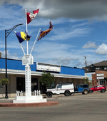
Day 8 - The big day. After a short drive made it to Dawson Creek Mile 0 of the Alcan. Stopped and took a few pictures of the big sign in the parking lot and met a lot of other travelers also starting their journey up, but I also wanted to stop at the original Alcan Mile 0 which is only a couple blocks away. This is the best picture I could get of it because it's in the middle of an active intersection and I didn't want to hold up traffic. I also happened to park right in front of the Dawson Creek visitor center where I picked up a lot of great maps for the trip. Also wanted to add that the visitors center in Grand Prarie was also a great stop, they had a complete excel spreadsheet printed out of all the stops along the alcan along with phone numbers and mile numbers. With all of the information I've picked up from these visitors centers I haven't actually opened up my Milepost that I bought for the trip.


1785486871682.png

I was excited to start the journey as soon as possible, but immediately saw this sign and had to detour

1785487194925.png

1785487194941.png

The rest of the day was just driving, rain, driving, eat, rain, and driving. Spent a lot of time exploring some of the dirt roads off the highway to lead to random streams and rivers.

1785488228834.png

Met some nice fisherman from Fort Nelson at the Sikanni Chief River who gave me a lot of great local advice on places to go and see. So, armed with local knowledge (and lack of other options in the area) we continued driving up to Fort nelson to catch the dinner buffet at Triple G hideaway.

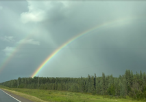
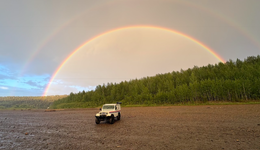
After dinner we went to check out one of the local camping spots along the Muskwa river, but the minute we hit the river bottom the rain started up again, so back up to town to get another hotel room. But at least I got an awesome picture of a double rainbow while I was down there.

1785487696815.png
 
Last edited:
Back
Top